A Social Network for New Jersey Hiking Enthusiasts
Stokes - short way to the Brink Rd shelter
Hi again,
I want to take a brief trip with some "non-hikers" to show them the view from the ridge in Stokes. I doubt we'll be able to do the trail from either Culver's gap or Crater Lake, so I thought it might be OK to come in from Bevans Road and walk up to the shelter and then up to the ridge from there. Anybody familiar with that route? Is there parking at the end of Bevans Rd? and how far is the walk?
Thanks!
Replies to This Discussion
-
Permalink Reply by Paul on
-
Well, I did finally take a trip to find Bevans road. And it didn't work out so great, although the road shows up on both Google maps and on Garmin's 24k Topo - and it even registers on my car's GPS.
Traveling on the W Owassa Turnpike, and just past the sign that says entering Hampton Twp. there is a small dirt track that appears, but it could very well be someone's driveway and there is nobody around to ask. There is no place to park at the base of the road.
So unless somebody local knows otherwise, the short answer to this question has to be "no".
-
Permalink Reply by Hank Hall on
-
I know-Holy old thread bump, but I actually ran across some information that may be useful to Paul and others who are curious about this. In my search to find old farms, homesteads, and lumber operations swallowed up by Stokes and the Gap I started doing research on Bevans (also known as Brink) Road. This quote is from a 2009 Open Space and Recreation Plan report from Frankford Township in Sussex County where Bevans Road is located:
Work with the Division of Parks and Forestry to identify Bevans Road as an
official access point into Stokes State Forest
http://www.frankfordtownship.com/uploads/open_space_rec_plan.pdf
What I take from the wording is that either Bevans is entirely on state property and simply isn't marked with any obvious signage. A search of the property tax records for the parcels there (Print screen key isn't working on my laptop so I can't post a screenshot) reveals that the ROW for the road passes through two private pieces, but one of them doesn't have an owner listed. That could mean that one of the owners was approached by the state to subdivide and sell off the portion that Bevans passes through to allow access and that the records haven't been updated yet. Other Google hits on "Bevans Road" Sussex reveal forum posts where people have stated that they parked there and hiked up without an issue.
-
-
Thanks, Hank. I just about forgot about this post, but I am still interested in finding that route. I'm on my way to check out the link you posted.
-
-
Here's the map of the parcels:
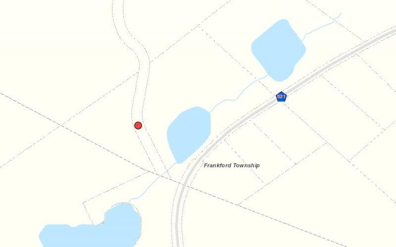
The road with the red dot is Bevans-you can see how it almost makes it to Route 521. The triangular shaped parcel to the left of it is the one that there is no data for. If I get a chance I'll call the park office at Stokes and see if they can tell me more.
About
Welcome to
NJ Hiking: Connect
© 2024 Created by njHiking.com.
Powered by
![]()